
Date: 31st March 2024.
Weather conditions: Not bad, but more sunshine would have been nice and there was a cold wind coming in off the sea.
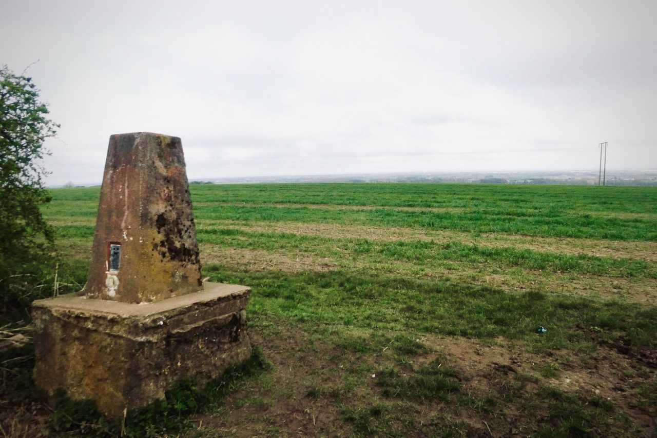
County Top bagged: The highest measured point in the local authority of North East Lincolnshire is a spot height of 384 feet/117m at roughly TF253968. The Times Atlas of Britain says that this point is called Wold Newton, but the Ordnance Survey use that label only for the little village a short distance to the west. As that is more logically a name for a settlement than a hill (if it was Newton Wold it’d be different) the hill seems officially nameless, but for convenience, let’s not argue with the Times here.
Historically this point was in Lincolnshire, Parts of Lindsey, of which Normanby Top, bagged more than four years ago now and only a few miles away, was the Top. It achieved County Top status in 1996 when North East Lincolnshire was created after the break-up of the short-lived Humberside.
By altitude Wold Newton ranks 145th of the modern Tops and 169th of the full list.
[ << Bow Brickhill Heath, Milton Keynes (79) | () ?? >> ]
Start and end point of walk: Started and finished at a small roadside parking place at roughly TF248966, marked on the map — and the road sign from the nearby A18 — as Beesby, although don’t expect to see a village: it is just a couple of farms (see also the route notes, though). There is room at this point for about four cars.

This point can’t be reached by public transport. The nearest place that can be is North Thoresby about two miles away: see the ‘access’ notes below. The walk took me precisely 90 minutes so we are not talking a major hike here. Starting and finishing in North Thoresby would be quite practical.
Pub at end: Nothing at the terminus. A couple of miles north up the A18 is the Landmark Cafe, which served me a cup of tea on the way in, but rather than a roadside caff this is more like a full-on, licensed restaurant. It would be a nice place to have lunch, although on weekends it looks like you’ll have to book a table in advance. There are pubs in North Thoresby, but I don’t know what they are like.
Distance walked: 4.1 miles/6.6km approximately.

Total ascent: 320 feet/97.5m approx.
Difficulty: ★★. This is a very straightforward walk and while I nearly gave one star, there are a couple of muddy sections that probably require boots. Maybe it would be one star in the dry season (a state of affairs we Britons have not experienced lately).
Ease of access: ★★. Starting and finishing at North Thoresby would make it possible to reach this walk using the #51 bus from Grimsby, which runs once an hour, though not on Sundays or Bank Holidays. But reaching Grimsby in the first place takes a while on the train, and I had previously worked out that the journey by public transport would take me at least four hours each way from home — whereas coming in the car took two each way.

The car is therefore the more practical option for this one. It’s about half an hour down the A18, which connects up to the end of the M180 motorway, somewhere just past Scunthorpe.
Scenic qualities: ★★★. Pleasant and peaceful countryside, with quite a good view from the later stages of the walk.
The area: North East Lincolnshire is one of the smallest non-metropolitan local authorities by area. It really just comprises the merged towns of Grimsby and Cleethorpes, and the cargo port of Immingham. None of these have a reputation for glamour and sophistication, but I’m sure the locals don’t care: they work for a living. Immingham is the UK’s busiest port, measured by gross tonnage, and insofar as Britain still has a fishing industry much of that still comes into Grimsby.
The Greenwich Meridian passes through the county, and while this is not the place that the line leaves the island (which is in East Yorkshire, across the Humber), Cleethorpes is the most northerly significant settlement on the Meridian (anywhere on it, worldwide), and this is the closest I have walked to 0º Longitude since ‘crossing the line’ near Oxted just over two years ago.
Map: I never got round to picking up the relevant Explorer (1:25,000) map for this one, but the 1:50,000 Landranger 113: Grimsby was adequate for planning, and on the ground a map is not really needed — this would be a tough walk on which to get lost.
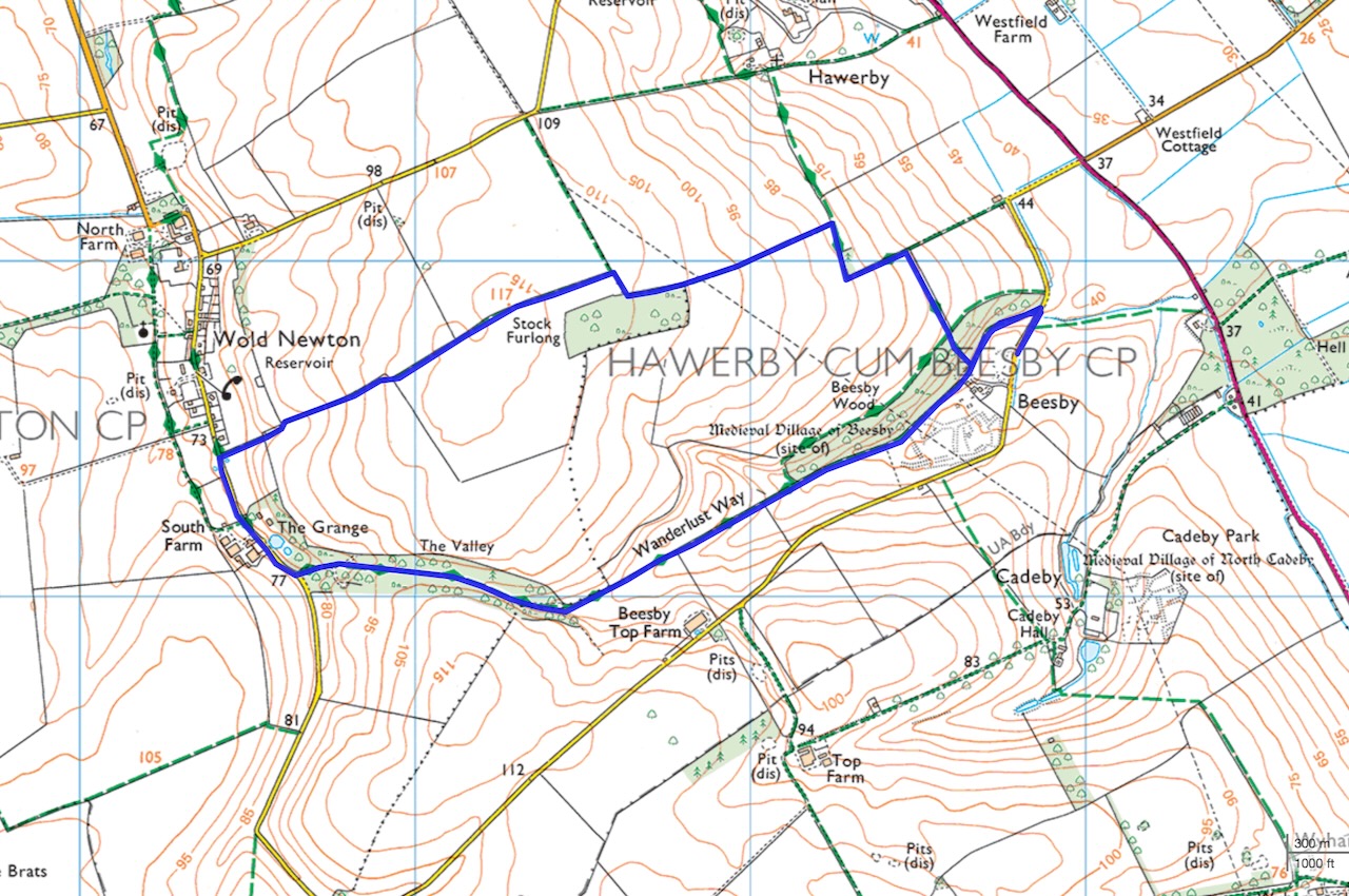
On this summary map, the summit is close by the ‘Stock Furlong’ label for the plantation, about two-thirds of the way round the circuit, which I went round clockwise.
Route: This is a straightforward, simple walk with almost no difficulties whatsoever: a couple of muddy patches are as bad as it gets. A fit jogger could probably run it in half an hour. But while there’s not much to it, there’s nothing dislikable about it either: a pleasant ramble for a fine spring day if you’re in the area. It’s easy to navigate and well-signposted.
One reason I started at Beesby is that the site of a ‘medieval village’ is marked there on the OS map and I wanted to check it out. From the parking space, go through the gate on the left and the path leads at first along the base of a high embankment that I eventually decided was the only obvious remnant of the village. Whatever else is there, you need an archaeologist’s eye to see it — as proven by this page, which I wish I’d read before my journey, to be honest. Even armed with this detail it will take a vivid imagination to conjure up a sense of what the place might have been like seven hundred years ago.

The path goes through a couple of gates and into another field which is the wettest section of the walk, there being various muddy dips in it that, with hindsight, are the ‘well preserved earthworks of part of the medieval openfield system surviving as ridge and furrow’ mentioned on the Historic England web page. Which is all very interesting, but you still need to tread carefully for a while.
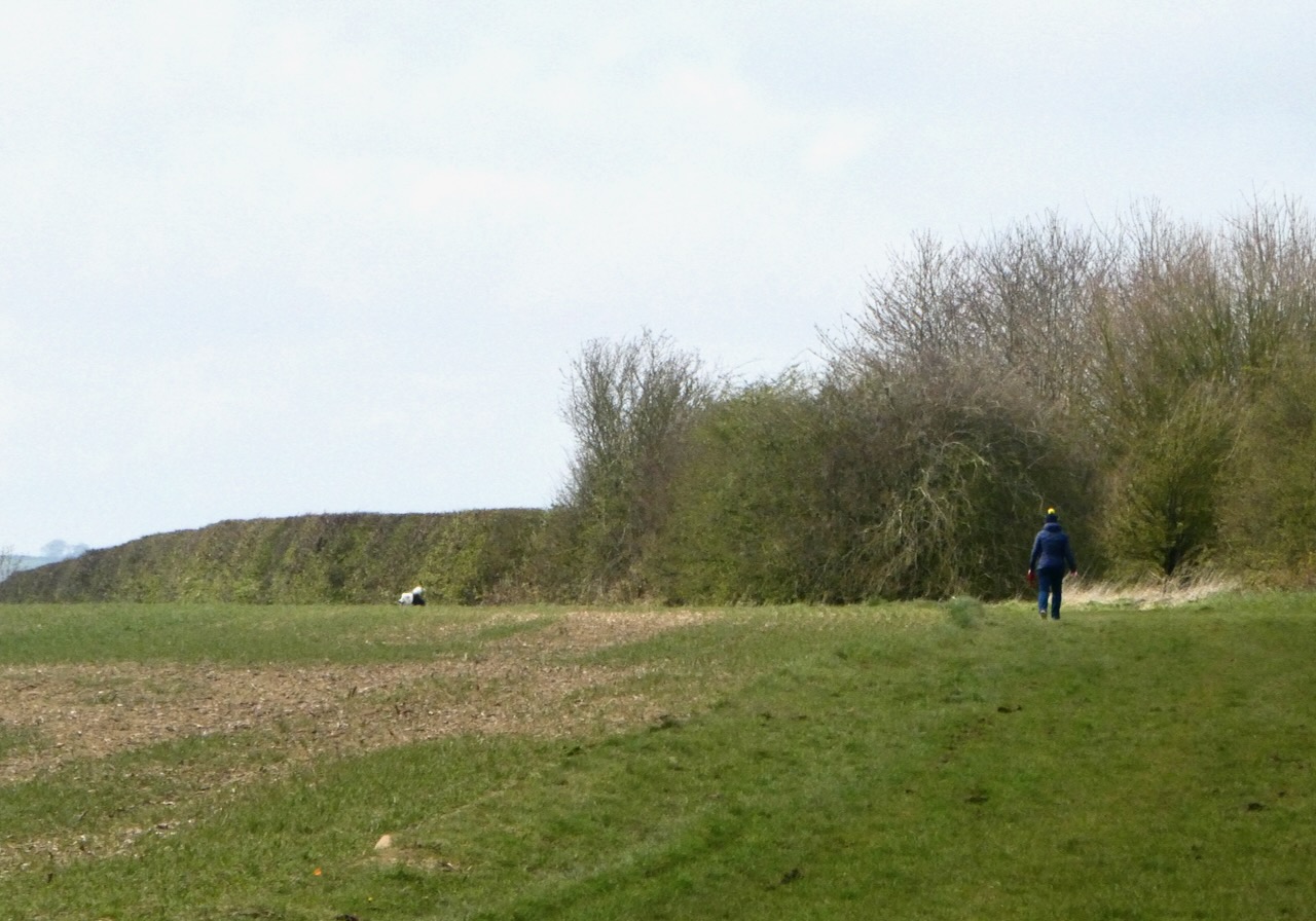
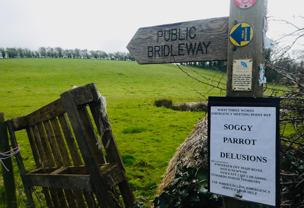
The path heads through a wooded valley and comes out onto a narrow tarmac lane, where turn right. This road heads into the village of Wold Newton, of which there is very little: a couple of dozen houses, a church and nothing else. Just after passing the sign for the village, turn right up a public bridleway. The signpost for this also provides the ‘What Three Words’ location, presenting a combination that ranks very high on any scale you might use: see the picture.
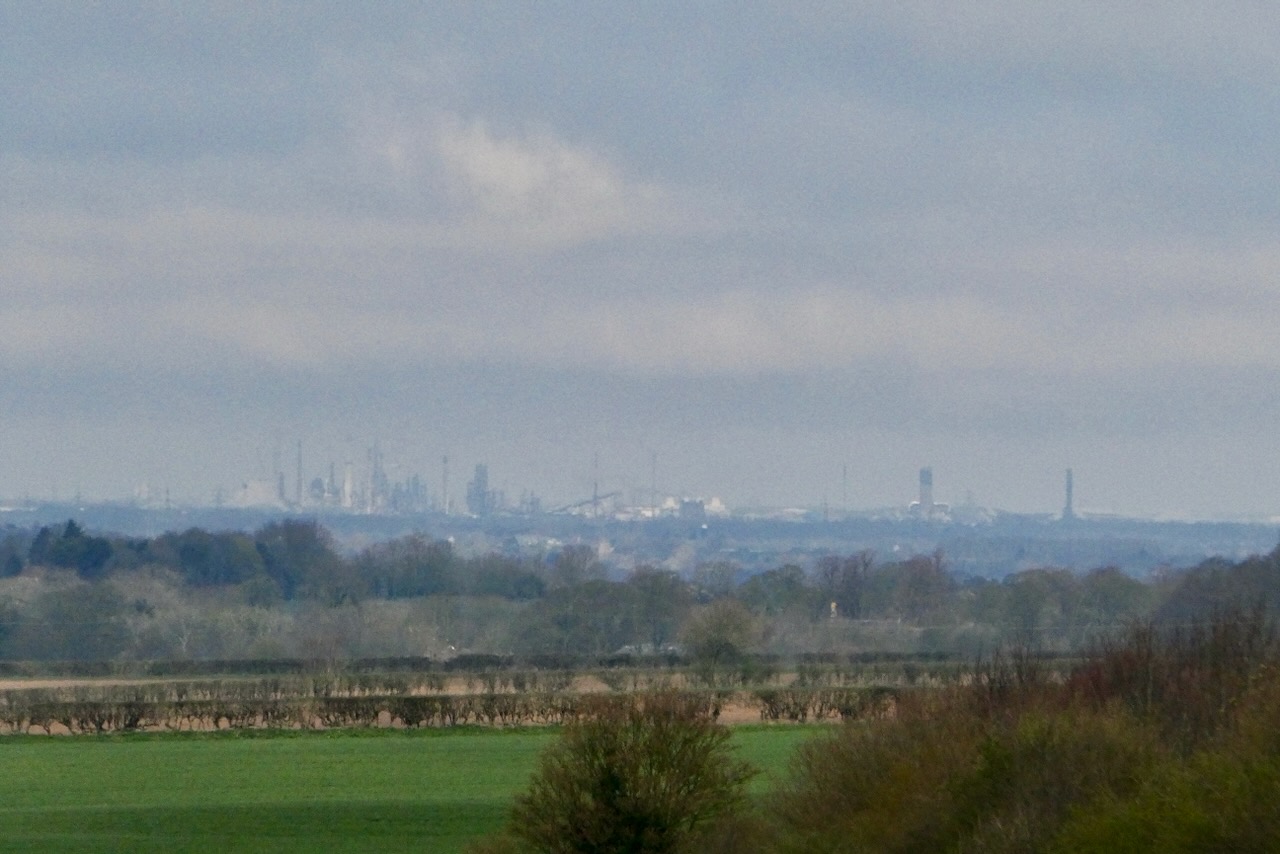
This bridleway is the day’s only real climb, ascending slowly and easily up to the summit. You can walk on either side of the hedge, with the views being better to the left (north). The towers in the distance, that look like they might be city skyscrapers, are in fact the oil refineries of Immingham. The highest point cannot be determined exactly, but it seems to be about a hundred yards before you come level with the corner of the plantation.
Totally unexpectedly, a short distance further down the path you pass a trig point (pictured): I say ‘unexpectedly’ because this is not marked on the OS map at any scale, and I honestly think that is the first trig I have ever encountered for which this is the case. These points are the whole basis on which the mapping of Britain is based: many of them might now be overgrown (see the ones on Ebrington Hill or last time on Bow Brickhill Heath for instance) or crumbling (Ben Lawers) but they’re still marked on the map. Not this one, though, and I do not know why.
Anyway, keep following the signposts. The views finally open up. The lower part of the Humber Estuary is visible ahead. The walking is easy as you drop down via a couple of right-angled turns and then, down the steepest slope of the day, through the ‘Bluebell Wood’ (and past the day’s only seat) and back into the field that supposedly contains the old village. Turn left, and return to the car.
Car crisis commentary: So it took me just fifteen days to break the commitment I made at the end of the last walk commentary, and end up not going to the Lake District at the first opportunity to complete my last Wainwright walk. It’s exactly because it will be the last one, in any meaningful sense, that I want to minimise any potential hassles, and so while the weather looked decent today, public transport wasn’t an option and the thought of driving to a tourist honeypot like Langdale or Seathwaite on Easter Sunday did not appeal.

I decided to do something that required a car anyway, and the reason for this is that soon, it looks like I’m going to lose access to it. I’ve been a member of my local car club for at least 18 years, and any time I have driven to one of these walks it’s been one of their cars that I’ve used. But unless something unexpected turns up, the club is going to close in the next couple of months.
The reason? A huge hike in insurance costs last year; the cost of this obligatory requirement tripled overnight, and many companies have now pulled out of offering any coverage at all. There is a story about it here. The System will always find a way, right? Read the emptiness of the comments made at the end of the story from the ‘Govern’ment droid, and the High Priest of the Association of British Insurers, and realise no one in Authority gives a shit.
Anyway as a result I decided I would pick one from the list of potential walks that were most easily done in a day trip from home, but by car. My thinking was, get one done now before they all become more inconvenient, at least for a while. Mickle Fell in the North Pennines was considered, especially as this was one of the few weekends of the year (there’s about one a month on average, so only about 25 days/year) when access to it is permitted, it being Ministry of Defence property. But I decided I wanted to let that one, and its miles of peat moor, dry out a bit more before risking it. Raw Head in Cheshire would probably have been just as much of a honeypot as Langdale. And I didn’t want to get up too early nor drive more than a couple of hours.
So Wold Newton it was. Hardly a pulse-quickener but decent enough, and no excess traffic either, even on the M62 on the way home. This was, definitely, my last CT walk until at least the last week of May, though; whether or not I get up Great End et al beforehand, in mid-April I’m getting off this island for a while.


One thought on “80: Wold Newton, North East Lincolnshire”