
Date: 4th November 2020.
Weather conditions: Glorious, an assessment that needs no qualification. The weather was one of two very persuasive reasons why I went out today. If you don’t know what the other one is, see the commentary.
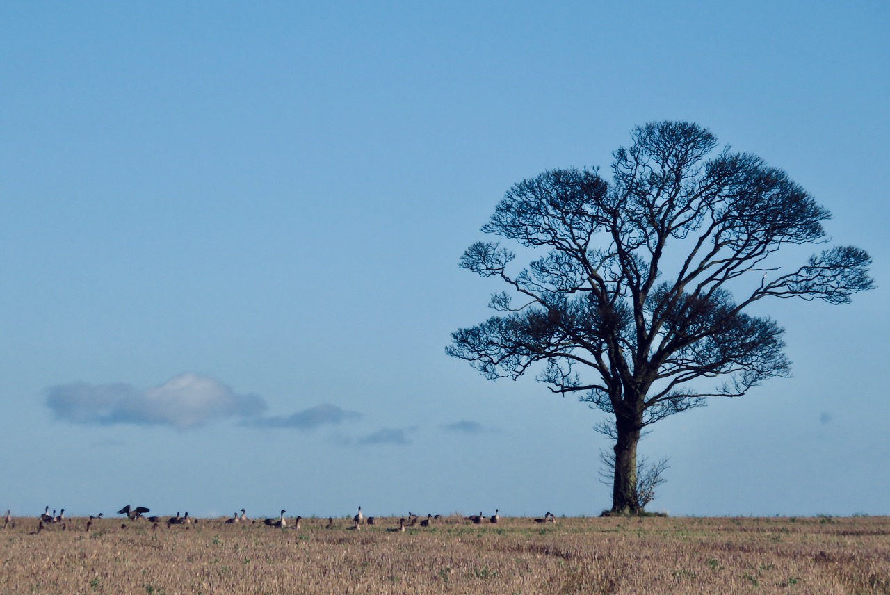
County Top bagged: Saxby Wold, which is 335 feet/102m above sea level and the highest point in the local authority of North Lincolnshire. The summit is at grid reference SE998172 and while not a prominent top is obvious on the ground, being marked by a covered reservoir.
It was in 1974 that this chunk of land was first divorced from its parent historic county, Lincolnshire, of which Normanby Top (bagged in March) remains the Top. In that year was formed Humberside, but as most people seemed to think this was a bad idea, in 1996 things changed again. With North Lincolnshire’s subsequent independence Saxby Wold attained the status of a County Top — albeit, the lowest one I have done so far (taking over from Langdon Hills in that respect). By altitude it ranks 152nd of the 172 modern tops, and 175th of the full list of 196.
Nevertheless, it does feel like a CT, being the highest point for miles around. As far as I can tell there is nothing higher on the whole OS Landranger sheet (see below) on which it stands. (Except, technically, the south stanchion of the Humber Bridge, which rises 510 feet above the water of the estuary.)
[ << White Coomb, Dumfriesshire (19) | (21) Hanging Hill, South Gloucestershire >> ]

Start and end points of walk: Started at Hessle railway station. This is served by services along the Selby – Hull line, although many trains go straight through the station without stopping, so check before you get on one. Finished at Barton-upon-Humber, from where there are buses back to Hessle.
I started the walk at 10.20am and finished at 3:00pm.
Pub at end: There are several pubs in Barton but some were not open today. I ended up in The Old Mill, where the barmaid/landlady eyed me rather suspiciously, but then again, maybe she’s just pissed off like the rest of us. Her pub did serve a decent pint, is right by the bus stop, and occupies a very distinctive building (still marked as a windmill on the 1:25,000 OS map).

Distance walked: 13.25 miles/21.5 km approximately. The second-longest of my 18 CT walks so far, behind only Ben Nevis.
Feet of ascent: 400 feet/120m at most.
Difficulty: ★★. As the low figure for ascent suggests, this walk is almost entirely flat. The only noticeable gradient tops out before your legs have even started registering it. It all takes place either on tarmac (and where it does, these roads are almost unused by traffic) or good, dry, hard-topped paths. But it is too long a walk to deserve only one star: I was quite footsore by the end.

Ease of access: ★★★. Some planning is required as only a few trains stop at Hessle and I had to watch the timing of connections between buses and trains on the way back, as the station is not all that near a bus stop. Barton does have a railway station of its own but it’s not very useful as from there you can only get a train to Grimsby. Nevetherless with attention to the details it was easy enough to do this one on a day trip.
Scenic qualities: ★★★. Don’t come expecting mountain country, but scenically it’s still pretty good. Not unexpectedly, the landscapes are similar to those a little further south around Normanby Wold — ploughed, chalky fields and big skies — but the views from Saxby Wold are enhanced by the prospects over the Humber estuary and its bridge.
The area: North Lincolnshire local authority is administered from Scunthorpe, by far its biggest settlement. This is not a place that most Britons would associate with glamour and sophistication, although I’ve never been there so I couldn’t tell you what it’s actually like. Barton seemed an OK kind of place, very suburban but with some attractive buildings in the centre. But like everywhere else at the moment it’s sort of shuffling along in a semi-coma.

By far the most interesting thing about the local area is the Humber Bridge. When this was completed in 1981 it was the longest suspension bridge in the world, a title it held until 1998, and it’s still the longest that one can legally cross on foot. It is a truly enormous structure, not just in terms of its length but also the height and bulk of the two colossal stanchions from which the vast support cables depend. All this is even more impressive considering that this isn’t really a principal route; in terms of the UK’s transport networks the bridge has only a local importance. Rumour has it that permission to build it was given by Harold Wilson in the late 1960s largely to help win a critical by-election in Hull.
Map: When I tried to buy it online, the relevant Explorer map was sold out, but I got round OK today with the 1:50,000 scale OS Landranger, 112: Scunthorpe and Gainsborough. This doesn’t cover the area north of the estuary, around Hessle, but you won’t need a map for this — if you can’t find the bridge from Hessle station you really aren’t trying very hard.

On the ground, this is a well-signposted route, but it’s probably still worth having some version of the map to hand, particularly when it comes to being sure about the actual summit. Much of it takes place along the Viking Way, with which I became acquainted (in all its muddy glory) on my walk to Normanby Top.
On this summary map, the starting point is at the top, and the summit more or less at the southernmost point of the route.

Route: This is a good and straightforward walk, particularly on a nice sunny day, but it is quite a long one. It could be shortened by starting in Barton as well as finishing there, but that’s not as easy a place to reach as Hessle, and in any case the Humber Bridge is worth adding to the walk as a prologue. I don’t see why misty or wintry weather should deter anyone from attempting it, but I would avoid it in strong winds, as I wouldn’t want to cross the bridge in a gale.
Come out of Hessle station and turn left, then at the end of that road, note the blue sign indicating the National Cycle route over the Humber Bridge. Following these signs led me first underneath the bridge and then round, up to the western side. There is a pedestrian/cycle path on both sides of the roadway, but in terms of the route it does not matter which side you end up on although the views are possibly a little better to the west.
The bridge is 1.4 miles long and it took me 32 minutes to cross, which was longer than expected though I did take many photographs. At the southern end you are directed down off the bridge onto a road running below, and at right angles to it.

Here, I sought advice from a walking couple about how to get to the obvious lane along the top of the levee that runs along the south bank of the Humber (pictured), and was directed through the yard of the building you see in this picture, the ‘Old Tile Works’, which is now a cafe and ‘craft centre’. I appreciated the advice and the friendly nature of its delivery, but it was incorrect: there is a path, but it goes through two locked gates, and the second one of these could not be climbed. I ended up having to negotiate a fence festooned with barbed wire. Looking more closely at the map, one needs to go further west along the earlier lane before heading for the bank.
The path along the levee will not be lost, but it does depart from the waterside on a couple of occasions. Two hours and nearly six miles from Hessle, I reached the edge of South Ferriby and stopped for lunch at a pleasant little roadside pond. From there, cross straight over the main road and ascend the lane ahead: the only real climb of the day, apart from the stairs up to the Humber Bridge. Keep going straight on as this becomes a rougher path for a while, takes you under a double line of pylons, goes back to being tarmac and, eventually, around two miles out of South Ferriby, passes a sign on the right pointing to Saxby.

Continue a short distance beyond this sign, then look to the left, where behind a white barrier, a track can be seen heading across the field and passing the summit of Saxby Wold and its covered reservoir — always a useful indicator that one has reached the top of a less prominent hill. (Radio or mobile masts are another, although this Top doesn’t have one of those.)
Carry on past the summit and then turn left at the end of the track. Pass the rather sinister barn that is the only evidence of Field House Farm (as marked on the OS map), and at the lane, turn right. After going down this for a short way, turn left along the green strip between ploughed fields that is signposted as a Public Bridleway. In fact this is our old friend the Viking Way again, and signs lead you along it as far as the attractive North Wold Farm (pictured).

Here turn right, and the rest of the way is on tarmac. This lane runs straight as an arrow as it drops down into Barton past suburban houses that seem unnecessarily large. At the end, turn left down Brigg Road, and you hit town at a cluster of pubs, some of which may even be open when you do this walk. The Old Mill is on the right, and a bus back to Hessle (and onward to Hull) can be caught from the stop just outside this establishment.
Big Bridge Commentary: Although I know I won’t get to do many of these walks for years (if at all), in my less occupied moments I do keep scanning the geography and logistics of all the Tops, thinking about which ones are possible trips from home. Judgments change as I do this. I’d written Saxby Wold off as a tricky bag simply because although Barton — the obvious base for it — has a train station, getting to that station is a faff, involving an epic journey via Doncaster and Grimsby that would take hours.
But then came one of those sudden moments of realisation, when I worked out how much easier it was to come in along the north side of the Humber and start my day by crossing the bridge on foot. Once I’d seen that the walk suddenly became a lot more appealing, and I resolved to make it my next trip. Hence today. It’s another low-altitude one, but what the hell.

The hike overstayed its welcome slightly — 13 miles feels like a lot for my 51-year old bones these days, however easy the gradients — but it was a good one, and certainly different to most of the others I’ve done so far. The Top itself was alright but the main attraction was the river. The Humber is a vast flow of water; not the longest river in the country even if you trace it back through its tributaries, but definitely the biggest. As you cross the bridge the drainage of about 20% of the whole of the UK is flowing under your feet.
The bridge is a prime suicide spot, and without safety barriers, one can see why. So I do hope that the rather furtive-looking, roughly 60-year-old guy who walked out in front of me to the bridge’s halfway point and then just waited there as I passed was not thinking of throwing himself off it. But let’s face it, prospects for the next four weeks are not promising. We’re in ‘lockdown’ again as of tomorrow.

Except it’s not ‘lockdown’. If it was, schools, colleges and universities wouldn’t be open. Amazon wouldn’t be allowed to oblige its robots to come to work in the warehouse, while independent high street bookshops are forced to pull down their shutters until 2nd December. Football matches can take place over there, where ‘there’ is a Premier League stadium, echoing and empty — but not there, at a local community club, or in a public park, benefiting the fitness and sociality of the masses but not making money for Rupert Murdoch. Pubs must shut despite there being no evidence that these are, in actuality, a major source of virus transmission.
What’s really coming tomorrow is the selective targeting of certain sectors of the economy. Digital interests are quite happy to see if we can get by without high street stores, without campuses, without any entertainment options other than what we pay them to stream to us. I’m a little shocked, but no longer ashamed, that the UK political voices expressing what I consider the most sympathetic opinions at the moment are among some of the more rabid Tories, like Richard Drax. He has observed, quite correctly, that even the government’s health adviser (Chris Whitty) used the phrase ‘economic devastation’ — in an argument for closing everything down! With ‘friends’ like him in power — who needs enemies? We’re doing it all to ourselves.

I had to get out today, the weather was too good, and it looks like this was my last chance for four weeks unless I now break the latest travel ban, a shocking imposition on a nation that used to think itself a free country. Even more shocking is that we might need people like Mr Drax to force things to open up again on Dec 2nd, a date that the moronocracy have been pretty explicit about but doubtless will still find reasons to waver around. Johnson probably hoped that his legacy was to be the PM who triumphantly led Britain out of the EU, but at the moment he’s more afraid of becoming the Clown Who Cancelled Christmas. Either way I will see you in December.

Good post and rant. Though I was somewhat discomforted to find myself agreeing with Nigel Farage about something (I.e being anti lockdown).
I took the day off on the 4th and drove to the South Downs to go up Ditchling and Firle Beacons in case I don’t get a chance to go up another hill this year. Obviously was county top day for both of us.
Yes, Ditchling Beacon is on the list… although I have been to the top of it many years ago, when I still lived in East Sussex.
Agreeing with Farage… now that really would be pushing it 🙂
Well he said he didn’t agree with lockdowns. My husband pointed out that ‘even a broken clock is right twice a day, even if only by accident’